


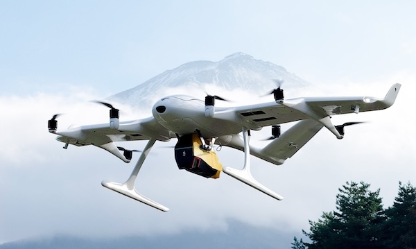
Wingcopter authorized partner in Japan, ITOCHU Corporation, has signed a MOU to collaborate on the practical use of Wingcopter’s long-range drones in aerial surveying together with PASCO Corporation and YellowScan Japan Co., Ltd. The companies initially plan to use the Wingcopter 198 in disaster management where drone-based surveying is playing an increasingly important role,
Carrying out these tasks is way easier and less risky with fixed-wing drones such as the Wingcopter 198 than with traditional human or aircraft-based methods, especially as about 70 percent of Japan's land consists of mountainous and hilly terrain, with steep slopes and short, fast-flowing rivers. Conventional multicopter drones, on the other hand, would not be suitable for such tasks as they are limited in range and coverage compared to the Wingcopter 198.
Under this MOU, YellowScan Japan's advanced LiDAR scanner "VOYAGER" will be used on the Wingcopter 198. By integrating this technology with PASCO's extensive expertise in operational quality and safety in aerial surveying, it is now possible to carry out long-distance and large-area surveys that were previously difficult to achieve without manned aircraft. In a single 45-minute flight, the Wingcopter 198 can scan 1,000+ hectares, simultaneously capturing LiDAR and RGB data, allowing the system to generate an exceptionally high point density and precision. This makes it suitable even for the most demanding applications.
The collaboration also promotes automation and labor savings in surveying tasks, thereby contributing to sustainable development in the surveying industry and reducing disaster risks.
Steffen Schubkegel, Senior Key Account Manager at Wingcopter commented: “Japan’s challenging terrain and exposure to natural disasters require the most reliable and advanced surveying technologies available. We are honored to work alongside ITOCHU, PASCO, and YellowScan - all recognized leaders in their respective fields - to combine our expertise and develop the best possible aerial LiDAR solution for this demanding task.”

Masaharu Sato, Deputy General Manager, Aerospace Department at ITOCHU Corporation stated: “By equipping the Wingcopter 198 with the industry-leading "VOYAGER" laser scanner, this collaboration overcomes the range and coverage limitations of traditional multi-copters. This solution is specifically designed to meet Japan's complex terrain and disaster mitigation requirements. Our goal is to foster innovation that automates surveying workflows and reduces labor requirements, ensuring swifter responses to natural disasters and minimizing associated risks.”
Takashi Shinazawa, Director & Senior Executive Officer Research & Development, Technology Strategy & Intellectual Property at PASCO Corporation said: “Based on PASCO’s more than 70 years of experience and expertise in aerial surveying since its founding, this POC encompassed survey planning, operational design, data acquisition, and evaluation. Going forward, we will continue to work in close collaboration with Wingcopter GmbH and ITOCHU Corporation to address a wide range of societal challenges through the utilization of geospatial information.”
Shinji Inaba, General Manager YellowScan Japan added: “YellowScan, through its Japanese subsidiary, is pleased to announce this strategic partnership with Wingcopter focused on high-performance systems: the YellowScan Voyager integrated with the Wingcopter 198. This unique combination of a high-end LiDAR solution and a long-range VTOL platform pushes the limits of drone surveying, enabling professionals to map multi-hectare areas in a fraction of the time previously required.
Through such partnerships, YellowScan continues to support professionals worldwide and to drive innovation further.”

International air charter specialist Chapman Freeborn has joined BlackBook Motorsport, the global business network connecting key stakeholders across Formula 1, NASCAR, MotoGP and the wider internatio...
From Learjets and Challengers to turboprops such as the Pilatus PC-12, different aircraft bring different capabilities to a medical flight. Sebastian Demiet, COO of MTI 24/7, explains why aircraft sel...
Information Design One AG, the Frankfurt-based aviation technology company behind the aFuel platform, has achieved a major operational milestone. During the first half of 2026, aFuel processed 50...
Desert Jet has broken ground on its long-planned ramp expansion at Jacqueline Cochran Regional Airport (KTRM), advancing a key infrastructure investment designed to accommodate rising business av...